Harringay, Haringey - So Good they Spelt it Twice!
Crouch End Neighbourhood Forum applies to Haringey for recognition
This is the latest mailshot from the Crouch End Neighbourhood Forum, which is on the very brink of applying to the London Borough of Haringey for official recognition under the Localism.
If you live / work / have an interest in Crouch End, or if you just happen to be close by you can support the forum by being a signatory or affiliating your local Residents' Association / Neighbourhood Watch / Lunch Club / Special Interest Group.
|
https://gallery.mailchimp.com/cb1025a24733dd53eb12c7fdf/images/76e6..." width="264" class="CToWUd a6T"/>
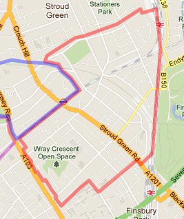
A Definition of Crouch End - in order to be accepted as a Neighbourhood Forum we must draw a line round what we believe is Crouch End, and then persuade Haringey that we have got it right. The blue line on this map shows where we are drawing the line at present. For a bigger version click here.
|
Tags for Forum Posts: crouch end neighbourhood forum
Replies to This Discussion
-
Admin for testingPermalink Reply by Hugh on -
I'd largely agree with the boundary with the exception of Park Avenue and Farrer which I'm very surprised to see within any Crouch End boundary outside of an estate agent's office.
-
Permalink Reply by Renato B on
-
Before even reading your message, I thought the same when I looked at the map.
-
Permalink Reply by Mark Crouch End on
-
Hello Hugh and Renato. I take your point, and we at the CE forum originally thought much the same. Though I guess we always knew that the Palace Gates corner was going to be tricky to categorise (as was much of the boundary between Hornsey and Crouch End - no line has existed previously of course).
What changed things was the field work - in our various map-plotting consultations 70% of responding residents on the two roads identified as Crouch End rather than Hornsey. So we investigated further, contacting local groups (Friends of Priory Park) and residents associations (incl. the Warner Estate RA), running two 'walkabouts' of the area - and canvassed all the businesses along the shopping parade that runs at the top of Park Road and Priory Road (in the end we had 30 responses from the immediate Farrar/Park Rd/Park Ave S area that we identify as 'Crouch End' - 57% Crouch End, 23% Hornsey, 20% don't know).
And the short of it is, that's what's on the map!
-
Admin for testingPermalink Reply by Hugh on -
Can't say fairer than that. It sounds like a thorough and effective methodology that I wouldn't argue wth at all. May I ask what your reposne rate from the residents was.
Thanks for dropping by to answer.
-
Permalink Reply by Hugo Read on
-
Great map. Talking about the same kind of area Hugh was, I'm amazed that Priory Park isn't in Crouch End. Having lived for 12 years in Palace Road (right by Priory Park) and used Priory Park every day, I very much considered it part of Crouch End and would have laughed if someone said otherwise. However, I suppose I can see that it can be called Hornsey too.
I find it odd (and unworkable?) that Park Avenue South is split seemingly randomly, with the last few houses before Priory Road being out. I presume that line is just after the alley that goes to the park. I would have thought the whole road needs to be in Crouch End. Same for Farrer (taking the opposite view of Hugh!). A split seems random, it needs to be in or out!
On that area in general, I would have though the whole triangle inside Park Road and Priory Road should be in. It's a simple and obvious boundary. That's just speaking as someone who lived for many years in that corner of Crouch End (but a confirmed Harringay resident now!).
Superb work though.
-
Permalink Reply by Omotn on
-
Two of our members approached the shopkeepers in the area. Most on the Priory Road side thought of themselves as Hornsey, while on Park Road the view was that they were in Crouch End. Hence the line along the back garden fences.
-
Permalink Reply by Arkady on
-
I'd argue that it's a mistake to include that part (or any) of Mount View Road. It's in Stroud Green Conservation Area like the vast majority of the road. Why not run the line along the garden fence-line as you have done elsewhere? The ridge is the physical and psychological boundary.
-
-
That was our original take on the boundary, but while the ridge is a physical demarcation, the reservoir is a much more significant psychological one. The great majority of residents on that stretch of Mountview think of themselves as Crouch Enders.
-
-
Fair enough! I'd be fascinated to see your canvassing results along the various parts of MVR if you have them.
-
-
Over 400 responses to the question "Do you live in Crouch End?" plotted by postcode
© 2026 Created by Hugh.
Powered by
![]()